Rudee Inlet:
The Rudee Inlet bite is starting to switch over from the summer bite to the fall bite. Though there are still a few lingering flounder, we have seen an increased bite in Speckled Trout. Anglers looking to target these fish would be best off using either a MirrOLure or Gulp on a light jig head. There are still some Croaker as well as some nice Spot biting, popular baits for these species would be best off using wither live Bloodworms or Squid. Don not forget to stop in our shop here at Rudee Inlet for all your Rudee Inlet fishing needs!
Inshore:
Sadly all boats are dockside today and we have no inshore trips scheduled. Over the past few days though boats that have fished inshore have had some pretty great catches of some nice sized Spanish Mackerel along with some decent Bluefish in the mix of things, There are still a few lingering Flounder that have been making an appearance from time to time, along with some Red Drum and small Sharks in the mix of things.
Offshore:
None of the fleet ventured offshore today unfortunately. Though just yesterday we had a member of the fleet return from offshore with 9 nice Wahoo and a few Mahi in the mix. Over recent days we have also had the fleet catching and releasing some White and Blue Marlin. There have also been some nice Tilefish to hit the docks lately.
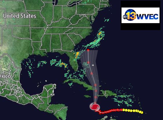
Hurricane Matthew:
Beyond that, it remains uncertain how close Matthew’s eyewall will pass near the northwest Bahamas later Thursday into Friday, and it is still too soon to determine which parts of the U.S. may be in danger late this week and next weekend. For now, ensemble forecast guidance suggests we can’t rule out at least tropical storm-force winds along the eastern Florida coast in the Thursday-Friday timeframe.Tropical Storm Force Wind ProbabilitiesChance of winds reaching or exceeding 39 mph.What will ultimately determine how close Matthew comes to at least the southeast U.S. coast (Virginia Tidewater southward) involves the timing and strength of upper-level high pressure along the East giving way to a southward dip in the jet stream, or upper trough, approaching from the central U.S. Here are the two scenarios:
- Bigger U.S. coastal threat: Stronger and/or later-departing upper high pressure system off/near the Northeast coast with weaker and/or later-arriving upper-level trough from the Plains.
- Lower U.S. coastal threat: Weaker and/or faster-departing upper high pressure system off/near Northeast coast with stronger and/or faster-arriving upper-level trough from the Plains.
Unfortunately, forecast guidance has not narrowed this uncertainty yet, which is not uncommon for a forecast beyond 4 days out.However, repeated runs of forecast guidance suggests at least a decent chance of tropical storm-force winds near the coast of the Carolinas and southeast Virginia Friday into Saturday.Even if Matthew stays well to the east of Florida and the East Coast, dangerous swells, coastal flooding and beach erosion are likely, particularly from the Virginia Tidewater south late this week into the weekend.We also cannot yet rule out a close call for the rest of the Northeast seaboard, including New England and even Atlantic Canada, later this weekend.All interests in the Caribbean Sea, Bahamas, U.S. East Coast and Atlantic Canada should continue to monitor the progress of Matthew. Preparations in Jamaica, Haiti, Cuba and the Bahamas should be well underway.
Check back with us frequently at weather.com for any important forecast updates.